General
Flood Zone Determination How to Verify Any Property Fast
September 22, 2026
16 min read
You're reviewing a property that looks profitable on paper. The comps support the resale value, the repair estimate seems manageable, and the seller wants a fast close. Then the lender's flood review places the structure in an AE zone, the insurer requests additional documentation, and your original offer no longer covers the carrying risk.
That's why flood zone determination belongs before you calculate your maximum allowable offer, not after inspection. A FEMA map label can affect insurance requirements, lender approval, construction decisions, and the buyer pool for your exit. The correct question isn't whether a parcel appears near water. It's whether the structure, loan, insurance requirements, elevation, and intended use fit together well enough to justify closing.
Why Flood Zone Status Can Make or Break Your Deal
A property can pass your initial numbers and still fail the deal test during lender review. The flood question often surfaces after inspections, repair negotiations, or a promised closing date, when your costs and timeline are already exposed.
Consider a flip near an AE boundary. The parcel may appear mostly outside the shaded area, yet the building's position determines the underwriting result. If the lender classifies the structure within a Special Flood Hazard Area, flood insurance may become a condition of a federally regulated or insured loan. That requirement can raise monthly carrying costs, change cash needed at closing, and reduce the buyer pool for the finished property.
Acquisition rule: Treat flood-zone status as a financing and exit assumption. Do not approve it from a map impression alone. Keep the supporting documents in the deal file.
Determination is not the same as a risk guess
A quick screen asks whether the property sits near a creek, drainage channel, coastline, or low-lying road. A formal flood zone determination identifies the applicable zone, base flood elevation, and floodway status from authoritative mapping and property-location data. FEMA describes flood zones as geographic areas with different flood risks, with the SFHA designation tied to the 1-percent-annual-chance flood threshold, as explained in the FEMA NFIP flood-zone guidance.
That threshold affects the transaction beyond the map color. It can prompt lender documentation, insurance review, local building requirements, and limits on renovation or expansion. A property outside an SFHA can still flood, but the lender's compliance process may differ from the process for a structure inside the designated high-risk area.
The framework also has a defined federal history. The National Flood Insurance Act of 1968 directed the federal government to identify and publish information on floodplain areas with special flood hazards, then establish or update flood-risk data over the following period. Federal agencies adopted the 1-percent-annual-chance flood as the minimum SFHA standard in 1971, and detailed-study paper FIRMs followed in 1973, according to FEMA's historical overview of the National Flood Insurance Act.
Where the deal decision changes
The zone label is an input, not the investment decision. Underwrite it alongside the structure's location, available elevation evidence, proposed work, financing, insurance, and exit plan.
Before approving the offer, confirm four points:
- Does the structure overlap the mapped area? A partial-lot condition can become a full lender issue when the building crosses into the boundary.
- Is a base flood elevation available? If so, compare it with the structure and lowest-floor elevations shown in reliable documents.
- Will the project trigger floodplain construction standards? Additions, reconstruction, utilities, and other substantial work may receive different treatment from ordinary repairs.
- Will the intended lender and insurer accept the file? A map screenshot can support initial screening, but it may not satisfy a formal review.
A high-risk mapped property can still work when the price, financing structure, insurance plan, and construction scope account for the exposure. The go/no-go test is documentary and financial: confirm the building's position, obtain usable elevation information, price the insurance and required work, and verify lender acceptance before the inspection period or financing contingency expires. If those items remain unresolved near closing, renegotiate the terms or walk away.
Where to Find Authoritative Flood Zone Information
A property can look clear in a listing portal while the building sits across a mapped flood boundary. Start with the effective FEMA map, then build a file that a lender, insurer, and local floodplain official can review. Search results, real estate portals, and third-party risk scores are useful for spotting questions, but they do not establish the final flood-zone determination.
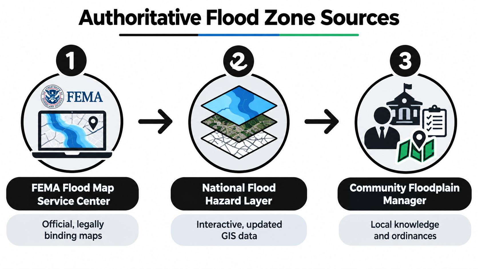
Use FEMA's Flood Map Service Center first. Search the property address, locate the applicable Flood Insurance Rate Map panel, and preserve the panel number, community, map status, and effective date. An older map may explain prior treatment, but the current effective map controls the initial underwriting conversation.
The National Flood Hazard Layer provides an interactive GIS view of effective FIRM data and Letters of Map Revision. Use it to compare the structure, parcel boundary, zone boundary, base flood elevation lines, and floodway. A parcel overlay that looks clean does not settle a building-location question, especially when the structure sits near a boundary or only part of the lot enters the mapped area.
Use local records to resolve the parcel
FEMA mapping supplies the starting point, while local administrators often explain how the map applies to the actual site. Contact the city or county floodplain administrator and ask about adopted ordinances, permitting requirements, elevation documentation, known map amendments, and whether the planned renovation requires additional review.
Local confirmation matters most when the property lies near a zone line or has changed since the underlying study. Flood-zone determination can draw on community consultation, topographic surveys, and statistical analysis of river flow, storm tides, erosion, wave heights, and rainfall. Treat those inputs as a reason to collect supporting records, not as a substitute for checking the structure's position.
For broader property research, investors can use a structured public records property search to identify tax, ownership, and record clues that may lead to additional documents. These records do not replace FEMA or local confirmation. They can, however, help locate prior permits, surveys, or alterations that affect the lender's review.
Keep a transaction-ready file containing:
- The FEMA search result and effective FIRM panel.
- A saved map view showing the building location, not only the parcel.
- Any available elevation certificate, survey, or site plan.
- Local floodplain administrator notes and applicable ordinance references.
- Seller disclosures, title materials, and prior determination documents.
- The lender's written position if its review differs from your preliminary finding.
Resolve conflicts before underwriting
If FEMA's map, county GIS, and seller documents disagree, identify the source of the conflict before setting the underwriting conclusion. Check whether each record uses the same address point, parcel configuration, map panel, and effective date. Then ask the local administrator and lender which document they require for the transaction.
A lender may order a formal flood determination through its own process. Your finding can guide the offer, but it does not override that requirement. Document calls, retain downloaded map files, and allow time in the purchase agreement or financing schedule for unresolved flood documentation. If the building's status, required evidence, or lender acceptance remains unclear, treat the deal as unready for approval.
How to Read FEMA Maps Elevation Certificates and Zone Labels
A property can look financeable until the house, not the parcel, lands on the wrong side of a FEMA boundary. Read the map as an underwriting document. First locate the building footprint, then confirm the zone label, panel legend, elevation data, and any lender-specific documentation requirement.
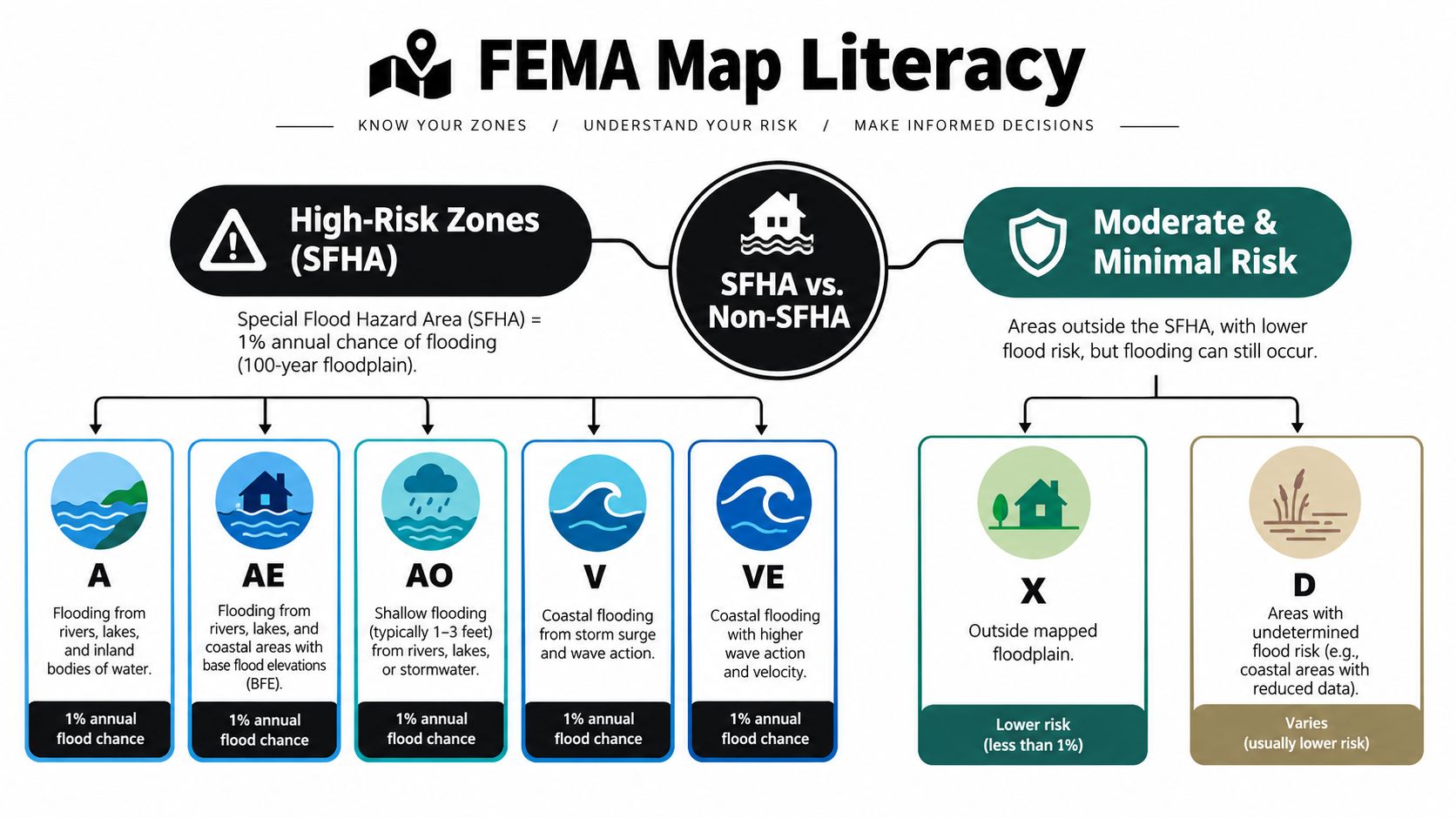
FEMA's Special Flood Hazard Area generally includes zones beginning with A or V. AE identifies a detailed study area with a mapped base flood elevation. A zones are also high-risk areas, but the map may provide less elevation detail. AO indicates shallow flooding with mapped depths. V and VE identify coastal hazards involving wave action, and VE also includes a base flood elevation.
Moderate- and minimal-risk areas commonly carry X labels. D means the flood hazard has not been determined. These labels support initial screening, not a no-risk conclusion. For a deal, the practical question is whether the structure lies within the SFHA and what evidence the lender, insurer, or flood determination provider will accept.
Read the map in the right order
Start with the panel legend. Identify zone colors, boundary lines, BFE lines, cross sections, floodway markings, and revision notes. Then place the structure on the map using a current survey, aerial reference, or reliable parcel drawing. Parcel boundaries and flood zones often diverge, so a parcel-level glance can produce the wrong acquisition decision.
A Base Flood Elevation is the elevation at which the base flood is expected to inundate the mapped area. It matters only when compared with a defensible elevation for the building, lowest floor, machinery, or proposed improvement. An elevation certificate can provide that comparison, provided it describes the correct structure and reflects the conditions relevant to the current underwriting question.
Review the floodway separately. It is the portion of a mapped floodplain reserved for carrying flood flows, and local rules may restrict fill, additions, reconstruction, or other encroachment. A building outside the floodway can still sit inside an SFHA. “Not in the floodway” does not resolve the flood review.
Partial-lot overlap is a structure question
Consider a flip parcel that straddles an AE boundary. The rear corner is shaded, while the house sits close to the line. An investor might rely on the larger unshaded portion of the lot. A lender or flood determination provider may instead examine the building location and request formal evidence.
Compare the map with a current survey, locate the foundation and additions, and review any elevation certificate. Check garages, enclosed porches, detached units, and planned additions separately. A proposed improvement can create a permitting or floodplain issue even when the existing main structure appears outside the zone.
Common reading errors include:
- Using the parcel centroid: A center point can hide a structure near the boundary.
- Ignoring map revisions: A newer effective panel or LOMR can change the regulatory result.
- Confusing zone labels: Being outside the SFHA does not mean the property cannot flood.
- Reading the BFE without a benchmark: An elevation has no decision value unless its reference datum and structure elevation are clear.
- Overlooking the lowest floor: Finished living space, utilities, crawlspaces, and enclosed areas may affect the review.
FEMA mapping created a map-based regulatory system, but every map remains a representation of terrain and water behavior. Historical program records describe the move from statutory identification requirements to detailed FIRMs and continuing updates. Use the map to screen the deal, then verify the physical facts that determine lender acceptance, insurance treatment, and the final go or no-go decision.
How to Request a LOMA or LOMR When the Map Is Wrong
A map correction can help when the official boundary doesn't match the property's documented elevation or a qualifying physical change. It isn't a shortcut for avoiding an inconvenient insurance requirement, and it shouldn't be treated as certain during escrow.
The first decision is whether the issue concerns natural ground elevation or a physical revision to the mapped area. A Letter of Map Amendment, or LOMA, is generally associated with a property or structure shown in the SFHA that may sit on natural ground at or above the relevant elevation. A Letter of Map Revision, or LOMR, addresses qualifying changes to the physical conditions or mapping representation, often involving engineered work or revised floodplain information.
Build the evidence before filing
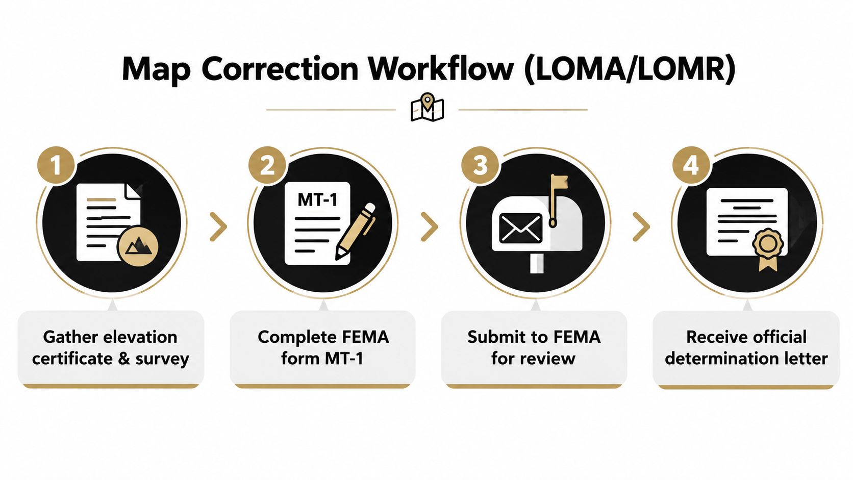
FEMA's review depends on precise documentation. A typical file may require:
- A licensed survey showing the structure, parcel, elevations, and reference datum.
- An elevation certificate completed for the correct building.
- Deed or ownership documentation.
- Site plans, engineering material, and photographs when they explain the request.
- The applicable FEMA map panel and a clear description of the disputed location.
- Local community acknowledgment or supporting information where required.
FEMA uses specific application processes, including the MT-1 application for certain property-based requests. Confirm the current form and submission instructions through FEMA before filing, because an incomplete package can create avoidable delays.
The National Oceanic and Atmospheric Administration's flood data resource reflects the practical role of maps in determining a location's zone, BFE, and floodway status. It also highlights why parcel-specific questions need more than a generic map explanation. A surveyor, engineer, local floodplain administrator, or flood-zone specialist can help determine whether the evidence supports a correction.
Manage the request inside escrow
Don't promise a buyer or lender that a pending request will remove the requirement. Put the status in writing, identify who pays for surveys and professional work, and establish what happens if FEMA or the lender rejects the request. If the transaction depends on the outcome, use a contingency or extension structure that matches the actual review risk.
Give the lender the complete submission package, not just a claim that “the map is wrong.” Ask whether the lender will accept a pending application, whether insurance must remain in place, and what official letter it needs before changing its determination. The lender's answer controls the financing timeline.
Use the following decision tree:
- The structure appears outside the mapped area: Verify the effective panel and structure location, then ask whether a formal determination is still needed.
- The structure appears inside the SFHA but natural ground may qualify: Investigate a LOMA with a licensed survey and elevation documentation.
- A development, fill, channel, or engineered change affects the mapped conditions: Discuss a LOMR path with the community and qualified technical professionals.
- The evidence is weak or the property needs immediate financing: Price the current determination rather than underwriting a favorable future result.
What Flood Zones Mean for Insurance Lending and Mitigation
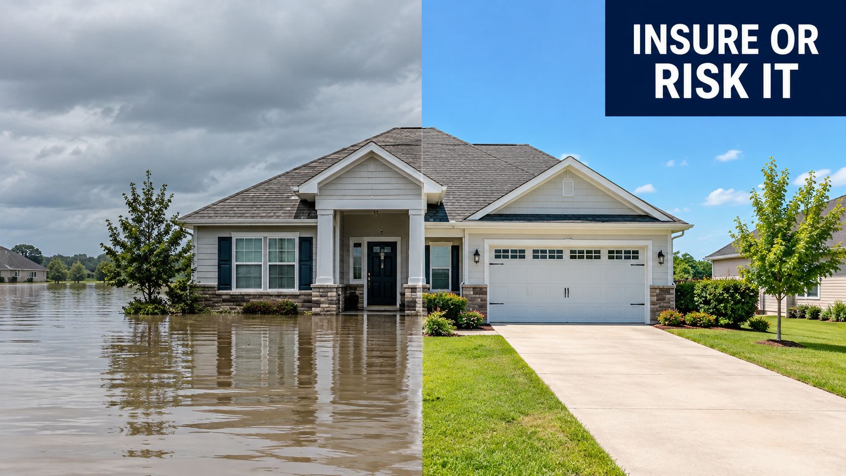
Flood-zone determination becomes financially meaningful when an insurer, lender, or building official converts the map result into a requirement. In an SFHA, a federally regulated or insured lender may require flood insurance for the improved property. In a moderate or minimal-risk zone, coverage may not be triggered in the same way by the map label, but flooding remains possible and a lender, insurer, buyer, or investment committee may still treat coverage as prudent.
The right comparison isn't “insurance or no insurance.” It's current carrying cost versus uninsured exposure, followed by a review of whether mitigation changes the underwriting outcome. Obtain quotes early, provide the elevation certificate if one exists, and ask the insurer how the structure, foundation, utilities, prior losses, and intended occupancy affect the policy.
Compare the lender's needs with the project plan
Hard-money financing adds another layer because the lender may focus on collateral protection, draw conditions, insurance evidence, and resale liquidity. Review the applicable hard money lender requirements before assuming the lender will accept a late flood-zone clarification.
Mitigation can improve resilience, but each measure has limits:
| Mitigation approach | What it can address | What to verify |
|---|---|---|
| Elevating mechanical equipment | Reduces exposure for systems located below expected flood levels | Confirm permits, utility connections, and elevation documentation |
| Flood vents | Allows water movement through certain enclosed spaces | Verify design, installation, and local code acceptance |
| Grading and drainage work | Helps manage site runoff and localized water | Confirm that work doesn't redirect water or violate floodplain rules |
| Floodproofing | May protect eligible nonresidential areas or systems | Obtain engineering and code approval before assigning value |
| Limiting below-grade improvements | Reduces damage exposure in vulnerable areas | Check whether the proposed use is permitted |
For a flip, mitigation only makes sense if the work can be completed, documented, insured, and explained to the resale buyer. For a hold, the calculation may include long-term maintenance, tenant disruption, financing renewals, and future map or ordinance review. Don't assign a resale premium to a mitigation feature until the local official, insurer, and lender agree on how they treat it.
Red flags that change the go or no-go answer
A mapped floodway crossing, missing elevation evidence, repeated water intrusion, unclear prior claims, unpermitted fill, or a planned addition near the boundary can turn a manageable property into a documentation problem. Local restrictions may prevent the renovation that supports your original ARV.
If the lender won't approve the insurance plan, the municipality won't confirm the intended work, or the correction request is speculative, revise the offer or walk. A cheap acquisition isn't cheap if the exit buyer faces unresolved financing friction.
Investor Due Diligence Checklist and Next Steps
Make flood review a pre-offer gate. You don't need a perfect engineering file before every conversation with a seller, but you do need enough verified information to avoid calculating MAO from an untested assumption.
Use this checklist:
- Confirm the effective map: Save the FEMA panel, community information, map status, and effective date.
- Locate the structure: Compare the building footprint with the zone boundary, not just the parcel outline.
- Record the zone label: Note whether the structure falls in an SFHA, moderate or minimal-risk zone, or an area with undetermined hazard.
- Check BFE and floodway status: Capture the panel's elevation and floodway information where available.
- Request existing documents: Ask for an elevation certificate, survey, permits, seller disclosures, and prior flood determinations.
- Call the local administrator: Confirm ordinances, permit triggers, past amendments, and planned work restrictions.
- Ask the lender early: Find out what determination, insurance evidence, and correction documentation it will accept.
- Test LOMA eligibility: Use documented elevation facts, not hope, to decide whether a correction request is realistic.
- Price mitigation accurately: Include professional fees, permits, construction, insurance, delays, and resale friction.
- Set a walk-away condition: Define the unresolved result that makes the property fail before you spend further capital.
A repeatable real estate due diligence checklist helps keep flood findings attached to the underwriting file rather than buried in email. Share the map, supporting documents, lender response, assumptions, and unresolved questions with partners before you finalize the offer.
The go decision is strongest when the structure's mapped status, elevation evidence, insurance path, financing terms, and renovation plan agree. Proceed when the risk is documented and priced. Renegotiate when the facts are solvable but expensive. Walk when the deal depends on an uncertain map correction, unavailable insurance, or work the local authority may not permit.
PropLab helps investors organize property records, identify risk flags, compare relevant comps, estimate repairs, and produce an offer-ready underwriting report that keeps flood exposure visible in the deal file. Visit PropLab to run the property analysis before you submit an offer, then share the documented assumptions with your partners or lender.
Tags
About the Author
P
PropLab Team
Real Estate Analysis Experts
The PropLab team consists of experienced real estate investors, data scientists, and software engineers dedicated to helping investors make smarter decisions with AI-powered analysis tools.
Free account
Underwrite your next deal in under a minute
3 free analyses, no credit card. ARV, rehab, comps and exit strategy in one report.
